Mount Pleasant's 11 main areas, from the Old Village to Carolina Park: ZIP codes 29464 and 29466, zoned high schools and Sept. 2026 home values.
Last checked Oct. 16, 2026. Sources: the Town of Mount Pleasant’s GIS map services (address points, subdivisions, zoning overlays, land use plan hubs, ZIP codes) and Settlement Communities report, OpenStreetMap, Charleston County School District’s school lookup map, the South Carolina school report cards, Zillow Research and the Census Bureau.
Mount Pleasant sits on the east side of Charleston Harbor and the Cooper River, joined to Charleston by the Ravenel Bridge. The town grew outward from the Old Village on the harbor, and most of it now lines a single spine, U.S. 17, which runs northeast toward Awendaw. I-526 comes in from Daniel Island and North Charleston and ends at U.S. 17, with exits at Long Point Road (28) and U.S. 17 (29 and 30). Highway 41 (S.C. 41) branches north from U.S. 17 to the Wando River. The town had 93,993 people in the Census Bureau’s 2020-2024 American Community Survey, according to its QuickFacts page.
Two ZIP codes cover almost all of it: 29464 in the south and west, from the Old Village to Belle Hall, and 29466 in the north. Public schools are run by Charleston County School District, which splits the town between two high schools, Lucy Garrett Beckham High and Wando High. School zones do not follow ZIP codes or neighborhood names, and the town limits are ragged, with unincorporated county land in between. Check any address with the district’s school lookup tool and Charleston County’s parcel viewer.
What this means for you
- Which high school: Beckham for the south and west of town, Wando for the north, with Seaside Farms split between them. Both were rated Excellent on their 2025 state report cards.
- Home values: the Zillow Home Value Index was $933,192 in 29464 and $835,506 in 29466 in September 2026; the town as a whole was $871,681.
- Getting out of town: I-526 is the only interstate, and its exits are all at the south end. From the northern areas it is 7 to 8 miles by road to Exit 28.
The 11 areas at a glance
Home values are the Zillow Home Value Index for the ZIP code most of the area is in, for September 2026; they are modeled typical values for the whole ZIP code, not sale prices. High schools are from the district’s attendance zones; where an area is split, the share is shown.
| Area | Main ZIP | Zoned high school | Typical home value in that ZIP | Guide |
|---|---|---|---|---|
| Old Village | 29464 | Beckham | $933,192 | Old Village |
| Shem Creek and Coleman Boulevard | 29464 | Beckham | $933,192 | Shem Creek and Coleman |
| Remley’s Point | 29464 | Beckham | $933,192 | Remley’s Point |
| I’On and Hobcaw | 29464 | Beckham | $933,192 | I’On and Hobcaw |
| Belle Hall and Long Point Road | 29464 | Beckham | $933,192 | Belle Hall |
| Seaside Farms and Rifle Range Road | 29464 (73%) | Beckham 73%, Wando 27% | $933,192 | Seaside Farms |
| Six Mile and Hamlin | 29466 | Wando | $835,506 | Six Mile and Hamlin |
| Brickyard | 29466 (94%) | Wando 94% | $835,506 | Brickyard |
| Park West | 29466 | Wando | $835,506 | Park West |
| Dunes West and Rivertowne | 29466 | Wando | $835,506 | Dunes West and Rivertowne |
| Carolina Park and Ten Mile | 29466 (88%) | Wando | $835,506 | Carolina Park |
Map
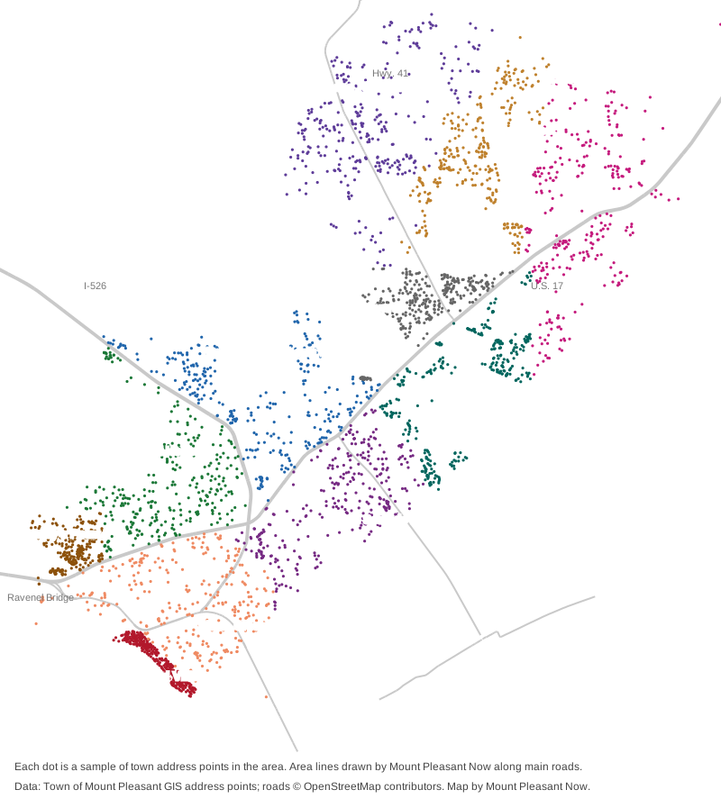
Map by Mount Pleasant Now from the Town of Mount Pleasant’s address points. Roads © OpenStreetMap contributors.
The south and west: ZIP code 29464
Old Village. The town’s historic district on the harbor, 37 blocks between Shem Creek and Whilden Street, with Pitt Street at its heart. Exterior changes need the approval of the town’s Historic District Preservation Commission. Zoned for Mt. Pleasant Academy, Moultrie Middle and Beckham High.
Shem Creek and Coleman Boulevard. The older, closer-in neighborhoods between U.S. 17 and the harbor, with the most addresses of any area in this guide, the town offices, Patriots Point and the shopping centers on Coleman and Ben Sawyer boulevards. Three elementary zones meet here.
Remley’s Point. A point on the Wando River north of the Ravenel Bridge, including Scanlonville, which 100 freedmen bought from the Remley Plantation in 1868. It has a county boat landing and a town dock.
I’On and Hobcaw. The neighborhoods along Mathis Ferry Road inside I-526, including I’On, Hobcaw Point and the Greenhill settlement community, with the county library’s Mount Pleasant branch.
Belle Hall and Long Point Road. Belle Hall, Snee Farm and the Snowden settlement community along Long Point Road, next to I-526 Exit 28, Palmetto Islands County Park and Charles Pinckney National Historic Site. Split almost evenly between two elementary zones.
Seaside Farms and Rifle Range Road. South of U.S. 17 between Bowman Road and Six Mile Road, around the town’s busiest shopping stretch. This is the one area split between Beckham and Wando high schools.
The north: ZIP code 29466
Six Mile and Hamlin. Historic settlement communities on U.S. 17 and Rifle Range Road, where the town’s Sweetgrass Basket overlay district runs and basket stands still line the road. Jennie Moore Elementary and Laing Middle share a campus here.
Brickyard. The neighborhoods between U.S. 17 and Highway 41 just north of their junction, named Brickyard Plantation on the town’s map.
Park West. A large planned community east of Highway 41, with the town’s Park West Recreation Complex, Laurel Hill County Park and three public schools on Thomas Cario Boulevard.
Dunes West and Rivertowne. Planned communities on Highway 41 toward the Wando River, with the Phillips settlement community, founded in 1878.
Carolina Park and Ten Mile. The town’s north end, with Wando High, Carolina Park Elementary, a county library branch and the historic Ten Mile community across U.S. 17.
Comparing towns
For how Mount Pleasant’s taxes, schools, home values and commute compare with its nearest cities, see Mount Pleasant vs Charleston vs Hanahan vs North Charleston. More in our guides to home prices, schools, property taxes, parks and trails, getting around and moving here.
How we built this
- The areas are named for places the Town of Mount Pleasant itself names: the subdivision groups on its subdivision map, the overlay districts on its zoning map, the hubs in its land use plan and the communities in its 2021 Settlement Communities report. Place names inside each area were checked against OpenStreetMap. The Old Village is the town’s historic district overlay.
- The lines between areas are ours, drawn along U.S. 17, I-526, Highway 41, Mathis Ferry, Bowman and Six Mile roads, and in the north along the town’s subdivision boundaries. The town publishes no official neighborhood map, and other people may draw the lines differently.
- ZIP codes, schools and counts come from the town’s file of 40,469 addresses inside the town limits. We placed each address in an area and checked it against Charleston County School District’s attendance boundaries (elementary zones for 2026-27, middle and high school zones for 2025-26). Ratings are from the state’s 2025 report cards.
- Distances on the area pages are measured on the OpenStreetMap road network and are not drive times.
- Left out: the Two Mile settlement community has no boundary we could map, so it is not placed in an area; Four Mile is described on the Seaside Farms page. Unincorporated county land between parts of the town is not covered. We found no town or county registry of homeowners associations, so the area pages do not list HOAs.
Frequently asked questions
What are the main neighborhoods in Mount Pleasant, South Carolina?
This guide splits the town into 11 areas named by the town: the Old Village, Shem Creek and Coleman Boulevard, Remley’s Point, I’On and Hobcaw, Belle Hall and Long Point Road, Seaside Farms, Six Mile and Hamlin, Brickyard, Park West, Dunes West and Rivertowne, and Carolina Park and Ten Mile.
What ZIP codes are in Mount Pleasant?
Two cover almost all of the town: 29464 in the south and west, from the Old Village to Belle Hall, and 29466 in the north, along Highway 41 and upper U.S. 17. A small part of the northeast end uses 29429.
Which high school will my Mount Pleasant address go to?
Charleston County School District zones the town between Lucy Garrett Beckham High, for the south and west, and Wando High, for the north. The line does not follow ZIP codes; Seaside Farms is split between the two. Check an address with the district’s school lookup tool.
What is the typical home value in Mount Pleasant?
The Zillow Home Value Index for Mount Pleasant was $871,681 in September 2026: $933,192 in ZIP code 29464 and $835,506 in 29466. It is a modeled typical value, not a sale price.
Is Mount Pleasant a city or a town?
A town. The Town of Mount Pleasant had 93,993 people in the Census Bureau’s 2020-2024 American Community Survey estimates and runs its own police, fire and trash services.
Have your say