Moderate tidal flooding is forecast near the late-morning high tide Thursday, when Long Point Road can flood. Tides peaked at 7.83 feet this week, short of major.
Tidal flooding is forecast to reach moderate levels again around the late-morning high tide Thursday. The tide gauge at Charleston Harbor is forecast to peak at 7.6 feet around 11 a.m., according to the NOAA National Water Prediction Service forecast for the gauge, issued at 10:45 a.m. Wednesday. At 7.5 feet, the weather service lists Long Point Road near Palmetto Islands County Park as a road that floods.
Updated Oct. 29: The morning tides peaked between 7.73 and 7.83 feet Sunday through Wednesday, in the moderate range. None reached the 8-foot major level that had been forecast. The tables below show the observed peaks and the forecast for Thursday to Saturday.
What happened this week
The National Weather Service in Charleston issued coastal flood warnings for coastal Charleston County on Sunday and Monday mornings, and canceled each early as the water came in lower than forecast. It then issued coastal flood advisories for Sunday evening and for Tuesday and Wednesday mornings, according to its alert records for South Carolina.
These are the observed high-tide peaks at the Charleston Harbor gauge, from the water prediction service:
| High tide | Observed peak | Flood category |
|---|---|---|
| Sunday morning | 7.82 feet | Moderate |
| Sunday evening | 7.09 feet | Minor |
| Monday morning | 7.73 feet | Moderate |
| Monday evening | 6.71 feet | Below flood stage |
| Tuesday morning | 7.83 feet | Moderate |
| Tuesday evening | 6.52 feet | Below flood stage |
| Wednesday morning | 7.83 feet | Moderate |
What comes next
The water prediction service forecast issued Wednesday shows the daytime tides easing:
| High tide | Forecast peak | Flood category |
|---|---|---|
| Thursday, around 11 a.m. | 7.6 feet | Moderate |
| Friday, around noon | 7.3 feet | Minor |
| Saturday, around 1 p.m. | 7.2 feet | Minor |
The weather service had not issued a coastal flood advisory for Thursday as of early Thursday. The evening tides are forecast to stay below flood stage.
The original forecast
This is what we reported Sunday, Oct. 25, when the weekend warning was issued.
The National Weather Service in Charleston issued a coastal flood warning for coastal Charleston and Colleton counties from 4 a.m. to 11 a.m. Sunday. It expected one to two feet of water above ground along shorelines and tidal waterways, and said the flooding “will render numerous roads impassable.”
The forecast on Oct. 24
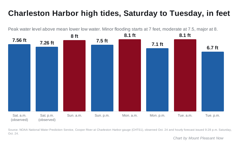
The weather service measures its warnings against the tide gauge on the Cooper River at Charleston Harbor. The NOAA National Water Prediction Service forecast for the gauge, issued at 9:28 p.m. Saturday, shows these peaks:
| High tide | Water level | Flood category |
|---|---|---|
| Saturday morning (observed) | 7.56 feet | Moderate |
| Saturday evening (observed) | 7.26 feet | Minor |
| Sunday morning | 8 feet | Major |
| Sunday evening | 7.5 feet | Moderate |
| Monday morning | 8.1 feet | Major |
| Monday evening | 7.1 feet | Minor |
| Tuesday morning | 8.1 feet | Major |
| Tuesday evening | 6.7 feet | Below flood stage |
The levels are measured above mean lower low water, the usual tide datum. At this gauge, minor flooding starts at 7 feet, moderate at 7.5 feet and major at 8 feet. The warning so far covers only Sunday morning. Monday and Tuesday are forecasts, and the weather service may issue new warnings for them.
What floods at each level
The weather service publishes what usually floods at each level on the gauge’s page. In and around Mount Pleasant, its list includes:
- At 7 feet: minor flooding of low-lying spots near the beaches on Sullivan’s Island and Isle of Palms.
- At 7.5 feet: Long Point Road near Palmetto Islands County Park in Mount Pleasant, and 12th and 15th streets on Isle of Palms.
- At 8 feet: widespread flooding in downtown Charleston, with numerous roads closed and some buildings affected. Impacts spread along the whole southeast South Carolina coast, with limited or no access to docks, piers and some islands.
For anyone crossing the Ravenel Bridge to work, downtown Charleston is where most roads close. The weather service names Lockwood Drive, Morrison Drive, East Bay, Market and Rutledge, U.S. 17 at state Route 61 and the area around MUSC.
For scale, the record at this gauge is 12.52 feet, set by Hurricane Hugo in 1989. The highest tide without a tropical storm was 9.86 feet on Dec. 17, 2023.
The Town of Mount Pleasant had not posted a flooding notice or a list of closed streets on its news page as of Thursday morning.
Rip currents at the beaches
The weather service in Charleston issued a rip current statement for South Carolina beaches through 8 p.m. Thursday. It said “rip currents can sweep even the best swimmers away from shore into deeper water.”
What it means for you
- Plan drives around the daytime high tide. The worst water comes in the hour or two either side of it: around 11 a.m. Thursday, and later each day after that, the forecast shows.
- Do not drive around barricades or through water of unknown depth, the weather service said.
- If you live or park near the marsh or a tidal creek, move cars to higher ground before the daytime high tide and protect anything stored at ground level.
- Expect Long Point Road near Palmetto Islands County Park to be wet around the high tide Thursday.
- Stay out of the ocean unless you are an experienced swimmer near a lifeguard. If a rip current catches you, float and swim parallel to the shore.
- Sign up for Charleston County’s CHSAlerts emergency notices, and check the latest NWS alerts for Mount Pleasant before you leave.
Our road construction and closures page lists other work across town. We will update this story if the weather service issues a new advisory or warning.
Have your say